
The Watzmann Traverse by Becky Bagnall
I live part time in Munich, Germany, as my partner is currently based here with work. This allows easy access to the eastern alps in Austria and the German Voralpen. We are lucky that we are able to do day trips hiking, climbing, kletterstieg (via ferrata) and in winter skiing, but also go further afield for weekends and weeks holidays that would have been our main two week holiday when living in the UK. We can be in the Dolomites in four hours – less than our journey time from home in the UK to Snowdonia! We love exploring the areas, and enjoying some of the lesser known areas, and places that are less accessible on holidays from the UK.
We had planned a week’s holiday in late July to Switzerland or eastern Austria to do some more mountaineering/climbing and 4000m peaks. It was well documented about the poor conditions of the high alps in France, and the slightly lower glaciers in the more central and eastern alps were hit just as much, if not more. We had previously abandoned a mountaineering trip to Groß Venediger (Austria’s third highest peak) due to the dreadful glacial conditions and so decided to base ourselves out of Munich for the week, mainly climbing and paragliding, with a couple of overnight trips. The luxury we have of this choice is amazing and I am very appreciative.
The Watzmann is situated in the Berchtesgaden area of SE Bavaria, surrounded almost entirely by Austria (near Salzburg). It is a popular destination for beautiful and distinct mountains and lakes, and infamous as the Eagle’s nest, situation up in one of the hills, was Hitler’s holiday home. My partner had wanted to do the Watzmann traverse since first visiting the Berchtesgaden a few years ago to do some landscape photography. The photo below was one he took in Autumn and shows the Watzmann on the right, with the Watzfrau (L) and Watzkind (middle). The traverse route goes from the spur at the front of the Watzmann where the hut is situated, up and over the three peaks, descends behind (can’t see in this picture) and around to the right hand side back to the valley.

We headed off midweek for an overnight in the hut, splitting the route up into a short ascent day, with the additional ascent, traverse and descent the following day. We had debated if we should do the route in one day or two, but decided to stay in the hut to enjoy the experience and have a slightly shorter day on the traverse without having to worry about the time. This was definitely the correct decision. The hut is lovely with amazing views and great food (even for a vegetarian) and although we were very quick walking up to the hut, and were under guidebook time on the traverse, the descent was long, quite loose in places, which slowed me down, and it was an extremely hot day so took us a little longer than the predicted time for the descent. Guidebook time is 12-14 hours valley to valley.
I would thoroughly recommend this as a great alpine day out. It is high, has plenty of exposure, amazing views and fun scrambling, much of which is protected by wire via ferrata style. . We clipped in at times as it was very exposed, and I did use the wire on occasion to assist with the ascent. There were others on the route who did without VF kit and others who were clearly finding it very challenging and using wire all the time. It wasn’t quiet – which we weren’t surprised at as this is a very popular route particularly for those coming from further north in Germany.
We started early to avoid the crowds and were very glad we did as didn’t get caught up in queuing or with those who were less experienced and maybe moving slower. The descent from the ridge to the Wimbachgrieshütte was very long, and there were parts of it that I didn’t enjoy very much (I don’t like descent at the best of times!) but was worth it given how good the ridge itself was! Below I’ve split up the route and included some pictures for inspiration.
Walk in to the Watzmannhaus
The walk into the Watzmannhaus was very straightforward, however we were concerned that we were going to get wet as the clouds were looking very ominous and the air was extremely hot and humid. We made good time up to the hut, with our walk taking just over 2 hours, with a guidebook time of 3.5 hours and a sign time of 4 hours, this did however result in us getting very hot and sweaty but we did avoid any rain!

Walking into the Watzmannhaus in front of the Kleiner Watzmann

Panorama over the Bärenkareck, Karkopf, Berchtesgadener Hochthron, Hoher Göll, Schniebstein and Kahlersberg

Evening light on the Hoher Göll

Sunset over the Berchtesgadener Hochthron
After an enjoyable evening eating good food, enjoying some beer and chatting to others at the hut we headed up to bed,. We had a surprisingly good night’s sleep given that we were staying in the “Lager” (dorm room) as it was split into two small sections and had plenty of windows – there were no ‘window wars’ that night, unlike experiences I’ve had in some of the French/Swiss huts!
Ascent to Hocheck
The next morning we decided to skip breakfast in the hut, so that we could get out before the crowds so that the ridge crossing would be more enjoyable. The walk up was straightforward with some small sections of scrambling, but even starting at 7am it was very hot in the sun. The views gradually improved as we ascended, and the view from the summit of Hocheck was wonderful.

On the ascent to Hocheck in the morning
Almost at the Hocheck summit

Wonderful morning view into Austria

Looking over the Gernhorn and Wagendrischelhorn towards the Großvenediger
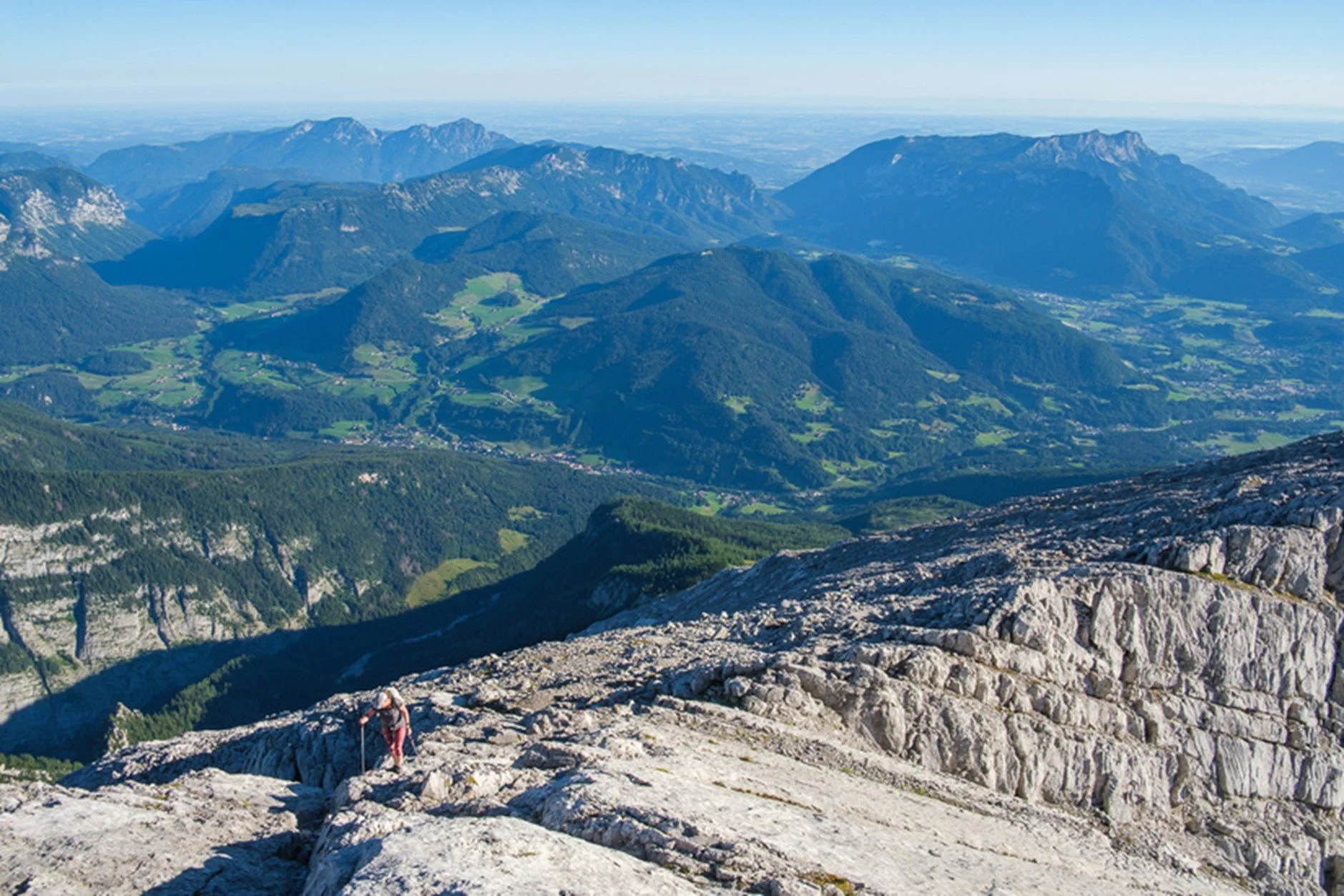
The Traverse
After quickly gearing up, we headed off on the traverse, which was wonderful. It was never difficult, but there was plenty of scrambling, loads of exposure, and brilliant views in every direction (including down to Königssee). We didn’t use our kletterstieg equipment very much, as it was mostly very easy, but it was certainly good to have it on some of the more exposed sections and a helmet was certainly a good idea given that there is some loose rock, and it is a very popular route. This is a high alpine route and well maintained with the DAV (German version of BMC) inspecting and replacing the metal work each year. However, it is not like the ‘sports’ via ferrata routes one often find in the Dolomites and some of the sections are quite long stemple to stemple with a wobbly wire. There aren’t any ladders and most of the wire is traversing or to aid with descent (going the route we did - which is the normal and recommended way). The klettersteig is there for protection, rather than as the aim of the day itself.

Me on one of the slabs on the traverse feeling a bit hot and tired I think!

On the traverse

Looking over the Watzmann Südspitze towards the Großglockner and the Großvenediger

Panorama from the Watzmann Mittelspitze

On an exposed descent

Fantastic exposed positions with wonderful views from the Watzmann Südspitze

Us on the Watzmann Südspitze (the last of the three main peaks) – the end of the wire protection

Lush green views down to the Königsee and Obersee

View from the Watzmann Südspitze
The Descent
We knew that the route had a lot of descent, over 2200m, but what we hadn’t quite prepared for was how loose and at times busy the descent was going to be. We initially focussed on the walk out to the Wimbachgrieshütte, which involved 1300m of descent over a very short distance. At least the views were nice for it. We kept our helmets on as there was a lot of loose rock. I was certainly impressed by the speed in which some others passed us – mountain goat -like trotting on down the slopes! I stuck with my poles and kept going, wishing I had brought a little more food with me (or perhaps had some breakfast!).

Me on the long descent
Eventually we made it down to the valley bed, both having run out of water, and as a result a little grumpy (me, not him). From here there was thankfully only a short easy walk to the Wimbachgrieshütte which was welcoming and had a large choice of cold drinks!

It wasn’t hard to imagine this valley filled with a glacier
The walk out
After enjoying a late lunch and many drinks at the Wimbachgries Hütte, we then had the remaining 800m and 8km to do back to the car. The path was really good for this section, so we made excellent time and were soon back at the car having had an excellent day out.
This is a fantastic route and one I’d definitely recommend. You need decent approach shoes (or boots), a helmet and for most people via ferrata (klettersteig) kit, harness and gloves. We were hot all day as there was no wind and few clouds, and wore T shirts and shorts but we both packed softshell and lightweight belay jacket, which we wore in the hut in the evening. We didn’t take rain coats as knew there wasn’t any predicted rain for 5 days after. Its not a route that I would recommend in wet conditions. Perfect conditions that we had are rare and we were lucky. I would think twice about doing it on a cloudy day as part of the magic of it is the views; the cloud inversions in the morning were stunning and the sunset beautiful. Plenty of food and water is essential as is a sunhat, sunscreen and sunglasses.
There are plenty of other mountains in the Berchtesgaden area to explore, with climbing, klettersteig and walking in abundance. There are climbing routes on various aspects of the Watzman itself, some of which are accessed via a boat ride along Könnigsee. It’s an area one could easily spend a week enjoying the mountains, lakes, history and local culture. Some of the villages are somewhat on the touristy side and can be pretty busy in the summer months, especially during school holidays, so pick your times well! Berchtesagden village is about 2hr 15 min drive from Munich airport, or Salzburg airport/train station is about 30 minutes away.

Route map and elevation profile.
Total distance: 23.32 km
Max elevation: 2693 m
Min elevation: 628 m
Total climbing: 2250 m
Total descent: -2167 m
Photographs all copyright A. Begley. Masterplan-Mountaineering.co.uk